“Winter returned,” said Bob Oravec, lead forecaster at the National Weather Service in College Park, Maryland.
The polar vortex of ultra-cold air usually stays penned up around the North Pole, spinning like a top. But sometimes it escapes or stretches down to the U.S., Europe or Asia — and that’s when large numbers of people experience intense doses of cold.
Studies show a fast-warming Arctic gets some of the blame for the increase in polar vortex stretching or wandering.
Snow and ice in forecast
By Saturday evening, widespread heavy snow was likely between central Kansas and Indiana, especially along and north of Interstate 70, where there was a high chance of at least 20 centimeters of snow. Part of the interstate was closed in central Kansas by the afternoon.
The storm was forecast to move then into the Ohio Valley, with severe travel disruptions expected. It will reach the Mid-Atlantic states Sunday into Monday, with a hard freeze expected as far south as Florida.
Severe thunderstorms, with the possibility of tornadoes and hail, were also possible ahead of the storm system’s cold front as it crosses the Lower Mississippi Valley, the National Weather Service warned.
Car wrecks
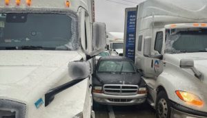
A fire truck, several tractor-trailers and passenger vehicles overturned west of Salina, Kansas. Rigs also jackknifed and went into ditches, state Highway Patrol Trooper Ben Gardner said.
He posted a video showing his boots sliding across the highway blacktop like an ice-skating rink.
“We are in it now,” Gardner said as he drove to the scene of an accident. Online, he begged for prayers and warned that some roadways were nearly impassable.
Freezing rain in Wichita, Kansas, sent authorities to multiple crashes in the morning, and police urged drivers to stay home if possible and watch out for emergency vehicles.
Governors in neighboring Missouri and nearby Arkansas declared states of emergency. Whiteout conditions threatened to make driving dangerous to impossible and heighten the risk of becoming stranded, forecasters warned.
Getting ready
Stores in Wichita were filled with shoppers stocking up on groceries in advance of the storm, and warming centers opened in churches and libraries.
Several businesses closed across the Kansas City area, and the school district in suburban Independence, Missouri, said it might need to cancel classes for one or more days.
“Get where you’re going now & stay put. If you must travel, consider packing a bag & staying where you’re headed,” the Missouri Department of Transportation said in a message on the social platform X.
The agency warned Friday that a shortage of workers could hamper the ability to clear roads.
In Columbus, Ohio, crews treated major roadways with anti-icing liquids.
“It will be a major headache,” said Tom Kines, a senior meteorologist with AccuWeather. “The storm not only has the snow threat to it but the ice threat.”
Power outages could be significant particularly south of the Kansas City area, Kines said.
Temperatures dip
Starting Monday, the eastern two-thirds of the country will experience dangerous, bone-chilling cold and wind chills, forecasters said. Temperatures could be 7 to 14 degrees Celsius below normal as the polar vortex stretches down from the high Arctic.
In Chicago on Saturday, temperatures hovered near minus 7-10 Celsius and around minus 18 C in Minneapolis, while dropping to minus 25 C at International Falls, Minnesota, on the Canadian border.
Disruptions extend southward
Virginia Governor Glenn Youngkin declared a state of emergency Friday evening ahead of the storm and noted it could impact people’s ability to vote in the state’s special elections Tuesday. In a statement on X, he encouraged residents to vote Saturday before the bad weather arrives.
A similar declaration was issued in Maryland, where officials in the historic state capital near Chesapeake Bay asked residents to remove vehicles from emergency snow routes. Annapolis also announced plans to open several garages on Sunday for free parking.
The National Weather Service predicted about 20 to 30 centimeters of snow for the Annapolis area, with temperatures remaining below freezing throughout the weekend.
In Baltimore, an extreme weather alert was issued instructing agencies to provide shelter and assistance for those in need. City officials said wind chills were expected to dip to minus 10.56 degrees Celsius overnight Saturday and remain in the teens through Tuesday.


